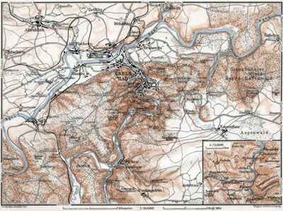
Karlsbad (Karlový Vary) and environs map, 1910 (second version)
$0.99 USD
Historical map of Karlsbad (Karlový Vary) and vicinity from 1910, in Czech Republic, produced by Wagner & Debes, at the scale of 1:50,000. Includes inset(s) at scale(s) of 1:75,000. Digitally restored. A part of the Discus Media 1900 Collection.
Looking for a valuable and original gift? Buy ...
Looking for a valuable and original gift? Buy ...
Geographic area:
Category:
Historical
Size:
4.81MB
Publication:
1910
Language:
German
Map bounds
Check nearby mapsWhat you get with Avenza Maps

Reliable mapping tools
Record GPS tracks, add placemarks, add photos, measure distances, and much more.

Locate yourself with GPS
Avenza Maps offline GPS app on your mobile device can locate you on any map, without WiFi or network connectivity.

The best maps by the best publishers
Download professionally curated digital maps on the Avenza Map Store from the best-renowned publishers.