

Digital map for use exclusively in the Avenza Maps app
1
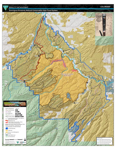
Dominguez-Escalante National Conservation Area Travel Map
Bureau of Land Management - Colorado
- Camping
- Cycling
- Hiking
- Hunting
- Off-roading
Free
Overview
The Dominguez-Escalante National Conservation Area (D-E NCA) is part of the BLM’s National Conservation Lands and is an administrative unit within the BLM’s Southwest District. It is located in western Colorado (Figure 1.1). The southwest boundary of the NCA planning area borders the ...
The Dominguez-Escalante National Conservation Area (D-E NCA) is part of the BLM’s National Conservation Lands and is an administrative unit within the BLM’s Southwest District. It is located in western Colorado (Figure 1.1). The southwest boundary of the NCA planning area borders the ...
Geographic area:
Category:
Parks & Forests
Size:
29.85MB
Publication:
2017
Language:
English
This product is available exclusively in digital format, for use only in the Avenza Maps app.
Map bounds
Check nearby maps Customer Reviews
3.0 Based on 1 Reviews
Write a Review Ask a Question - Reviews
- Questions
Filter Reviews:
C
08/24/2021
Customer
Denver, Colorado, United States
Dominguez-Escalante National Conservation Area Travel Map
What you get with Avenza Maps

Reliable mapping tools
Record GPS tracks, add placemarks, add photos, measure distances, and much more.

Locate yourself with GPS
Avenza Maps offline GPS app on your mobile device can locate you on any map, without WiFi or network connectivity.

The best maps by the best publishers
Download professionally curated digital maps on the Avenza Map Store from the best-renowned publishers.