
Digital map for use exclusively in the Avenza Maps app
2
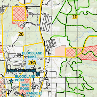
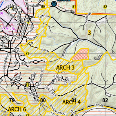
Fort Leonard Wood Hunting and Fishing-Aerial View with Contours
- Fishing
- Hunting
$1.99 USD
This map can be used to navigate through Fort Leonard Wood.
Features include hunting areas, archery only areas, cantonment areas, no hunting areas, off limit areas, installation boundary, firebreaks, points of interest, special ponds, access control points, range gates, contours, cemeteries, c...
Features include hunting areas, archery only areas, cantonment areas, no hunting areas, off limit areas, installation boundary, firebreaks, points of interest, special ponds, access control points, range gates, contours, cemeteries, c...
Geographic area:
Category:
Hunting & Fishing
Size:
27.61MB
Publication:
April 2024
Language:
English
This product is available exclusively in digital format, for use only in the Avenza Maps app.
Map bounds
Check nearby maps Customer Reviews
5.0 Based on 2 Reviews
Write a Review Ask a Question - Reviews
- Questions
Filter Reviews:
A
01/04/2025
Anonymous
Hunting the Fort
Very easy to use, even for a couple of old guys, lol
JG
09/27/2021
Joseph G.
Saint Robert, Missouri, United States
Great add ranges
If you could at the range #s and TA#s like on a topographic map, I’d say this map would be 10x better
What you get with Avenza Maps

Reliable mapping tools
Record GPS tracks, add placemarks, add photos, measure distances, and much more.

Locate yourself with GPS
Avenza Maps offline GPS app on your mobile device can locate you on any map, without WiFi or network connectivity.

The best maps by the best publishers
Download professionally curated digital maps on the Avenza Map Store from the best-renowned publishers.