
Digital map for use exclusively in the Avenza Maps app
Hiawatha NF – Rapid River National Cross Country Ski Trails Map
- Hiking
- Skiing
Free
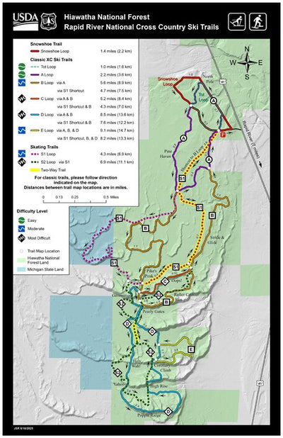
This map shows the routes of the nearly 16 miles of cross country ski trails and the 1.4 mile snowshoe loop at the Rapid River ski area on the West Zone of the Hiawatha National Forest. Located 7 miles north of Rapid River, MI off of Highway 41, the trails are open to classic and skate skiing and...
Category:
Trails
Size:
23.72MB
Publication:
June 2025
Language:
English
This product is available exclusively in digital format, for use only in the Avenza Maps app.
Map bounds
Check nearby mapsWhat you get with Avenza Maps

Reliable mapping tools
Record GPS tracks, add placemarks, add photos, measure distances, and much more.

Locate yourself with GPS
Avenza Maps offline GPS app on your mobile device can locate you on any map, without WiFi or network connectivity.

The best maps by the best publishers
Download professionally curated digital maps on the Avenza Map Store from the best-renowned publishers.