
Digital map for use exclusively in the Avenza Maps app
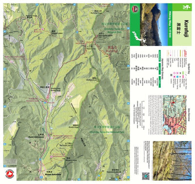
Kurofuji 黒富士 Hiking Map (Chubu, Japan) 1:17,500
- Hiking
Free
Located in the Southwestern part of the Chichibu-Tama-Kai National Park and part of an ancient volcano that also includes Mt Magari and Mt Tachioka, Kurofuji (黒富士 1633m “Black Fuji”) is an intermediate level hike best done in Spring and Autumn. Proceeding carefully a short way south of the summit...
Geographic area:
Category:
Trails
Size:
24.95MB
Publication:
March 2025
Language:
English, Japanese
This product is available exclusively in digital format, for use only in the Avenza Maps app.
Map bounds
Check nearby mapsWhat you get with Avenza Maps

Reliable mapping tools
Record GPS tracks, add placemarks, add photos, measure distances, and much more.

Locate yourself with GPS
Avenza Maps offline GPS app on your mobile device can locate you on any map, without WiFi or network connectivity.

The best maps by the best publishers
Download professionally curated digital maps on the Avenza Map Store from the best-renowned publishers.