

Digital map for use exclusively in the Avenza Maps app
Postcode District Map: Greater London
$14.99 USD
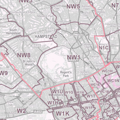
This Postcode District map of Greater London is an excellent planning tool. Use it to plan sales territories, marketing campaigns and mail drops. It shows Postcode Districts (e.g. SE10) and also Postcode Areas (e.g. SE). The Postcode boundaries are overlaid on detailed mapping based on Ordnance ...
Geographic area:
Category:
Tourist
Size:
44.42MB
Publication:
2011
Language:
English
This product is available exclusively in digital format, for use only in the Avenza Maps app.
Map bounds
Check nearby mapsWhat you get with Avenza Maps

Reliable mapping tools
Record GPS tracks, add placemarks, add photos, measure distances, and much more.

Locate yourself with GPS
Avenza Maps offline GPS app on your mobile device can locate you on any map, without WiFi or network connectivity.

The best maps by the best publishers
Download professionally curated digital maps on the Avenza Map Store from the best-renowned publishers.