Digital map for use exclusively in the Avenza Maps app
3
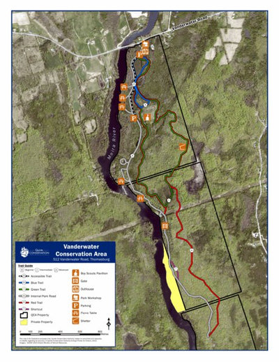
Vanderwater Conservation Area
- Hiking
Free
Vanderwater Conservation Area at 512 Vanderwater Road, Thomasburg ON is located along the banks of the Moira River. Visitors can explore a trail network consisting of 16 km that will lead them through mature forests and to the Moira River where the water cascades over a series of limestone steps.
Geographic area:
Category:
Parks & Forests
Size:
7.46MB
Publication:
2021
Language:
English
This product is available exclusively in digital format, for use only in the Avenza Maps app.
Map bounds
Check nearby maps Customer Reviews
4.3 Based on 3 Reviews
Write a Review Ask a Question - Reviews
- Questions
Filter Reviews:
- trails
- changes
- area
- sense
04/30/2023
Anonymous
I recommend this product
Map is ok.
I wouldn't use this map if you were really lost in an area. It is ok for a general sense of where you are.
03/06/2023
Anonymous
I recommend this product
VANDERWATER CONSERVATION MAP
Good map of the trails'
11/14/2022
Anonymous
I recommend this product
Probably time of year but we went down on trail but couldn’t tell how far it went.
Excellent. There is some minor changes to the trails that might be new that don’t show.
What you get with Avenza Maps

Reliable mapping tools
Record GPS tracks, add placemarks, add photos, measure distances, and much more.

Locate yourself with GPS
Avenza Maps offline GPS app on your mobile device can locate you on any map, without WiFi or network connectivity.

The best maps by the best publishers
Download professionally curated digital maps on the Avenza Map Store from the best-renowned publishers.