

Digital map for use exclusively in the Avenza Maps app
1
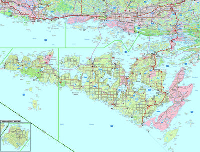
WMU 43A & 43B Manitoulin Island – Ontario Hunting Topo
- Backroading
- Camping
- Fishing
- Hiking
- Hunting
$9.99 USD
This topographic hunting map covers Wildlife Management Units 43A, 43B and 44 on Manitoulin and Cockburn Islands in northern Ontario. Featuring 1:20,000 scale water and road data from the popular Backroad Mapbook series, the maps clearly mark Wildlife Management Units, along with Crown land/priva...
Geographic area:
Category:
Hunting & Fishing
Size:
24.07MB
Publication:
2022
Language:
English
This product is available exclusively in digital format, for use only in the Avenza Maps app.
Map bounds
Check nearby maps Customer Reviews
5.0 Based on 1 Reviews
Write a Review Ask a Question - Reviews
- Questions
Filter Reviews:
A
09/28/2024
Anonymous
I recommend this product
Manitoulin 43a 43b
Map is very good like all othered I have used from Avenza
What you get with Avenza Maps

Reliable mapping tools
Record GPS tracks, add placemarks, add photos, measure distances, and much more.

Locate yourself with GPS
Avenza Maps offline GPS app on your mobile device can locate you on any map, without WiFi or network connectivity.

The best maps by the best publishers
Download professionally curated digital maps on the Avenza Map Store from the best-renowned publishers.