Albuquerque Balloon Festival Utilizes Avenza Maps
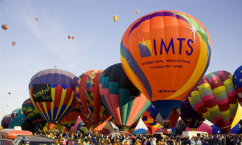
Every year hundreds of thousands of people from all over the globe travel to Albuquerque, New Mexico for the largest international ballooning event. During this nine-day fiesta, guests are able to view hundreds of colorful and unique hot air balloons touring the skies over 350 acres of Balloon Fiesta Park. Because the event covers such a large vicinity, Information Systems Manager, Mike McKnight, explained that the need for a clear, easy to use, map was not only important for the pilots, but for the guests as well and so McKnight went searching for a digital solution.
Avenza Maps - a mobile app developed by Avenza Systems, Inc., a leading developer of cartographic software - allows organizations and individuals that publish maps to upload digital versions of their maps for use in the app, at no cost. The maps can easily be downloaded onto a mobile device to view. Paired together with the device's GPS, the app provides the best of all worlds – the ability to read details clearly like a paper map, find your location with GPS and also identify direction.

When McKnight discovered that the Avenza Maps app could offer crystal-clear, interactive digital maps, he was thrilled. “I had been looking for something like this for years.” McKnight explained, “Most companies that made GIS conversions for maps used equipment that was just too small; and the larger PDF conversions were only able to be viewed with a laptop. When you’re hundreds of feet above the ground in a hot air balloon, a bulky laptop or for that matter, a jumbo-sized paper map just isn’t suitable.”
With Avenza Maps, balloonists and guests can download maps from the Avenza Map Store 24-hours a day. Through this technology, pilots as well as tourists traveling to this extraordinary ballooning event can easily prepare well in advance, quickly and conveniently.
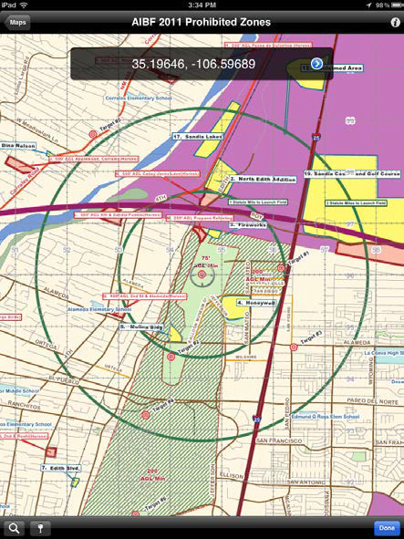
With the use of Avenza Maps, McKnight was able to transfer large 5’x3’ traditional paper maps to digitized, interactive PDFs. This simple transfer of data from traditional maps to digitized PDF garnered approval from the pilots. “Over a period of several days, a paper map of this size can get easily abused and cumbersome for pilots that need to navigate over a set course,” said McKnight. “The beauty of accessing maps through the PDF Maps app is that pilots can view them on their tablets and know exactly where they are in the sky– no more fussing with big, bulky paper maps that need to be folded and refolded. Pilots appreciate the fact that they can just scroll with the touch of your finger” McKnight stated. And all this can happen offline, hundreds of feet above the ground. With Avenza’s high-quality maps, balloon pilots are able view their location in relation to restricted areas and stay clear of prohibited zones such as airport flight paths and ranches that may have livestock which are easily frightened.
The Albuquerque Balloon Fiesta first began utilizing Avenza Maps in 2009, with only a dozen pilots. “The few balloon operators that used the technology really found it useful. With Avenza Maps, they could see their geographical coordinates as they moved, and that’s an essential feature that we could never get with traditional maps,” McKnight shared.
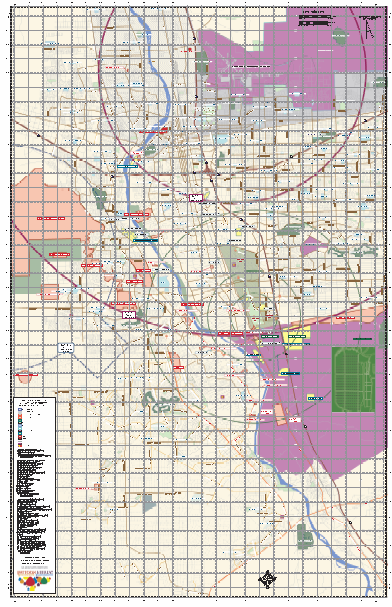
Minimizing the chance of pilots drifting into unsafe zones that could potentially damage their balloons or the property below them, Avenz Maps ensures that both balloon operators and enthusiasts can appreciate the experience and enjoy the views.
The maps have grown in popularity at the Albuquerque Balloon Fiesta and this year McKnight expects to see several hundred pilots using teh Avenza Maps app for navigation. “In regards to the event as a whole, I believe these maps have really helped us grow and evolve. We just love the technology behind them and I see this event evolving using the Avenza Maps.”
In the future, McKnight hopes to make the event more tourist-friendly by providing a way in which crowds could track the movement of particular balloons. He’s aware he’ll need to put a few more hours into developing a functioning map before it comes to fruition, but he knows the technology is there and more importantly, a growing base of fans willing to use it at such an interactive event.