

Digital map for use exclusively in the Avenza Maps app
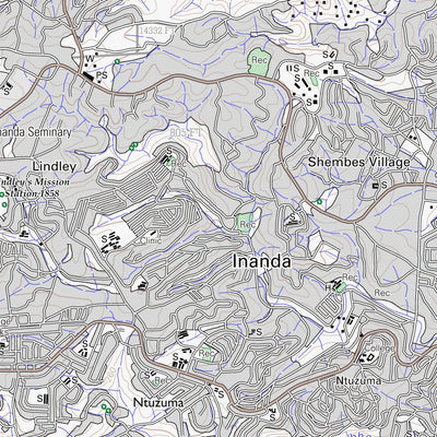
2930DB INANDA
Chief Directorate: National Geo-spatial Information
Free
This is a 1:50000 scale topographic sheet of the Inanda area. It is part of a series consisting of a total of 1913 map sheets covering the entire South Africa. A standard 1:50000 topographical map covers a rectangle of 15 minutes of latitude by 15 minutes of longitude or approximately 640 square ...
Geographic area:
Category:
Topographic
Size:
19.89MB
Publication:
2013
Language:
Afrikaans, English
This product is available exclusively in digital format, for use only in the Avenza Maps app.
Map bounds
Check nearby mapsWhat you get with Avenza Maps

Reliable mapping tools
Record GPS tracks, add placemarks, add photos, measure distances, and much more.

Locate yourself with GPS
Avenza Maps offline GPS app on your mobile device can locate you on any map, without WiFi or network connectivity.

The best maps by the best publishers
Download professionally curated digital maps on the Avenza Map Store from the best-renowned publishers.