

Digital map for use exclusively in the Avenza Maps app
1
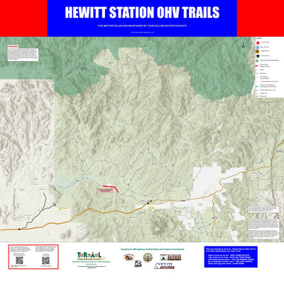
Tonto National Forest - Hewitt Station OHV Trails
- Off-roading
This map shows off-highway vehicle accessible roads and trails in the Hewitt Station area of the Tonto National Forest.
Please see descriptions of roads and trails in the legend of the map.
This publication is a pilot project from the Tonto Recreation Alliance (TRAL) non-profit volunteer ...
Please see descriptions of roads and trails in the legend of the map.
This publication is a pilot project from the Tonto Recreation Alliance (TRAL) non-profit volunteer ...
Geographic area:
Category:
Trails
Size:
54.79MB
Publication:
August 2021
Language:
English
This product is available exclusively in digital format, for use only in the Avenza Maps app.
Map bounds
Check nearby maps Customer Reviews
5.0 Based on 1 Reviews
Write a Review Ask a Question - Reviews
- Questions
Filter Reviews:
03/06/2022
Anonymous
I recommend this product
HEWITT STATION MAP
I greatly appreciate the efforts of the TRAL group to develop and publish this map. It is an excellent and important aid to all of us that travel there. However it needs to be updated. It doesn’t match ground truth in all cases
What you get with Avenza Maps

Reliable mapping tools
Record GPS tracks, add placemarks, add photos, measure distances, and much more.

Locate yourself with GPS
Avenza Maps offline GPS app on your mobile device can locate you on any map, without WiFi or network connectivity.

The best maps by the best publishers
Download professionally curated digital maps on the Avenza Map Store from the best-renowned publishers.