

Digital map for use exclusively in the Avenza Maps app
1
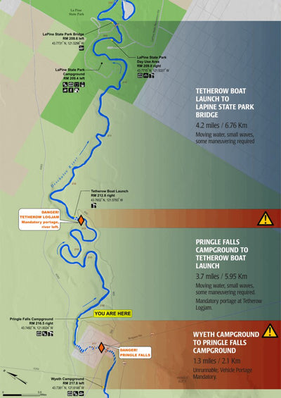
Deschutes Paddle Trail: Wyeth Campground to La Pine State Park
- Hiking
- Paddling
Free
The Deschutes Paddle Trail includes 95 miles of the Deschutes River from Wickiup Reservoir in the south to Lower Bridge in the north and 26 miles of the Little Deschutes River, along with ten of the largest Upper Cascades Lakes. Because the Deschutes River is the source of water for agricultural ...
Geographic area:
Category:
Parks & Forests
Size:
3.34MB
Publication:
February 2021
Language:
English
This product is available exclusively in digital format, for use only in the Avenza Maps app.
Map bounds
Check nearby maps Customer Reviews
5.0 Based on 1 Reviews
Write a Review Ask a Question - Reviews
- Questions
Filter Reviews:
C
09/29/2021
Customer
Bend, Oregon, United States
Paddle map
I have the Deschutes river map hardbound but love having it on my phone
What you get with Avenza Maps

Reliable mapping tools
Record GPS tracks, add placemarks, add photos, measure distances, and much more.

Locate yourself with GPS
Avenza Maps offline GPS app on your mobile device can locate you on any map, without WiFi or network connectivity.

The best maps by the best publishers
Download professionally curated digital maps on the Avenza Map Store from the best-renowned publishers.