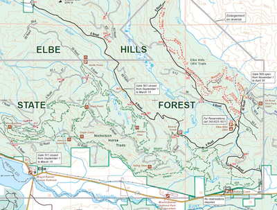


Digital map for use exclusively in the Avenza Maps app
3
Elbe Hills and Tahoma State Forests
Washington State Department of Natural Resources
- Cycling
- Hiking
- Horseback Riding
- Skiing
Free
This map shows recreation sites and trails in the Elbe Hills and Tahoma state forests near Mount Rainier. Managed by the Washington State Department of Natural Resources (DNR), Elbe Hills and Tahoma state forests are timber-generating working forests that provides opportunities for hiking, mounta...
Geographic area:
Category:
Parks & Forests
Size:
11.46MB
Publication:
November 2015
Language:
English
This product is available exclusively in digital format, for use only in the Avenza Maps app.
Map bounds
Check nearby maps Customer Reviews
5.0 Based on 3 Reviews
Write a Review Ask a Question - Reviews
- Questions
Filter Reviews:
- iPad mini
- service
- problem
01/28/2022
Anonymous
I recommend this product
Riding the trail with excellent maps
Great and easy to use. No service, no problem because it's downloaded on my iPad mini 5.
C
12/06/2021
Customer
Portland, Oregon, United States
Great map, roads clearly defined ,gps tracking work awesome.
C
08/23/2021
Customer
Yakima, Washington, United States
Elbe Hills and Tahoma State Forests
Maps were great with trail names and accurate tracking information.
What you get with Avenza Maps

Reliable mapping tools
Record GPS tracks, add placemarks, add photos, measure distances, and much more.

Locate yourself with GPS
Avenza Maps offline GPS app on your mobile device can locate you on any map, without WiFi or network connectivity.

The best maps by the best publishers
Download professionally curated digital maps on the Avenza Map Store from the best-renowned publishers.