

Digital map for use exclusively in the Avenza Maps app
Estes Park, CO Exploration Map for Sightseeing
- Backroading
- Camping
- Fishing
- Hiking
- Off-roading
This product can also be purchased as part of the following bundle(s).
- 10-map FrontRange Bundle: FtCollins EstesPk DenverE-W CastleRk Bailey CoSpgs PikesPk Pueblo CanonCty
- 14ers of Colorado - High Country Recreation Maps Bundle
- 4 Map Bundle NW of Denver, CO (4 x100K quads): DenverWest, Estes Park, Steamboat Springs, & Vail
- 5 Detailed "Maps Near Denver" Bundle: Estes Park, Denver West, Denver East, Bailey, & Castle Rock
- Enchilada Bundle - collection of 29 of our 100K- and 250K-scale recreation and exploration maps
Free
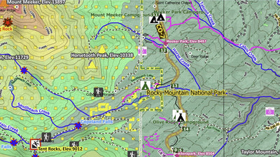
Excellent detailed & comprehensive map for navigating and exploring the on- and off-road areas near Estes Park, CO including Rocky Mountain National Park, Indian Peaks Wilderness Area, Never Summer Wilderness Area, Grand Lake, and both east & west sides of the Continental Divide.
MAP H...
MAP H...
Geographic area:
Category:
Parks & Forests
Size:
107.88MB
Publication:
June 2023
Language:
English
This product is available exclusively in digital format, for use only in the Avenza Maps app.
Map bounds
Check nearby mapsWhat you get with Avenza Maps

Reliable mapping tools
Record GPS tracks, add placemarks, add photos, measure distances, and much more.

Locate yourself with GPS
Avenza Maps offline GPS app on your mobile device can locate you on any map, without WiFi or network connectivity.

The best maps by the best publishers
Download professionally curated digital maps on the Avenza Map Store from the best-renowned publishers.