Digital map for use exclusively in the Avenza Maps app
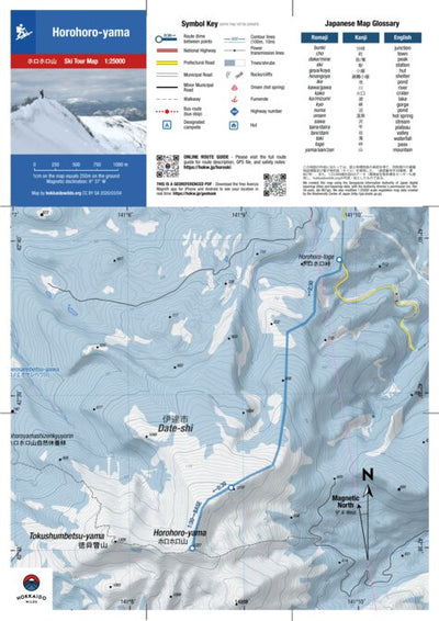
Horohoro-yama Ski Touring (Hokkaido, Japan)
- Skiing
Free
Horohoro-yama ホロホロ山 (1322m) is the twin of Tokushunbetsu-yama 徳舜瞥山 (1309m), connected via a high level ridge. It’s not the most popular of ski objectives as although the easiest access route starts from the high point on Prefectural Route 86, this only reopens in the final week of April. Moreover...
Geographic area:
Category:
Topographic
Size:
4.11MB
Publication:
March 2020
Language:
English, Japanese
This product is available exclusively in digital format, for use only in the Avenza Maps app.
Map bounds
Check nearby mapsWhat you get with Avenza Maps

Reliable mapping tools
Record GPS tracks, add placemarks, add photos, measure distances, and much more.

Locate yourself with GPS
Avenza Maps offline GPS app on your mobile device can locate you on any map, without WiFi or network connectivity.

The best maps by the best publishers
Download professionally curated digital maps on the Avenza Map Store from the best-renowned publishers.