Digital map for use exclusively in the Avenza Maps app
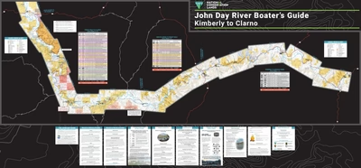
John Day River Boater's Guide Kimberly to Clarno
Bureau of Land Management - Oregon
- Camping
- Fishing
- Hunting
- Paddling
Free
The John Day River is one of our nation’s longest free-flowing river systems outside of Alaska, draining nearly 8,100 square miles of central and northeast Oregon. Elevations range from 265 feet at the confluence with the Columbia River to over 9,000 feet at the headwaters in the Strawberry Mount...
Geographic area:
Category:
Hunting & Fishing
Size:
15.1MB
Publication:
February 2024
Language:
English
This product is available exclusively in digital format, for use only in the Avenza Maps app.
Map bounds
Check nearby mapsWhat you get with Avenza Maps

Reliable mapping tools
Record GPS tracks, add placemarks, add photos, measure distances, and much more.

Locate yourself with GPS
Avenza Maps offline GPS app on your mobile device can locate you on any map, without WiFi or network connectivity.

The best maps by the best publishers
Download professionally curated digital maps on the Avenza Map Store from the best-renowned publishers.