Digital map for use exclusively in the Avenza Maps app
Bundle
3
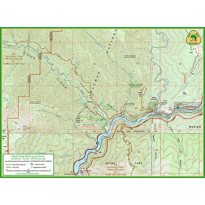
Pauls Creek Point hike
Sacramento Valley Hiking Conference
Free
These are the three maps needed to drive to and hike the Pauls Creek Point up-and-back easy dayhike in the Plumas National Forest.
The hike description is here: http://www.chicohiking.org/ValleyFoothill/Pauls-Cr-Pt.htm
The hike description is here: http://www.chicohiking.org/ValleyFoothill/Pauls-Cr-Pt.htm
Geographic area:
Category:
Topographic
Size:
20.56MB
Publication:
April 2021
Language:
English
This product is available exclusively in digital format, for use only in the Avenza Maps app.
Map bounds
Maps included in this bundle
This bundle contains 3 maps


What you get with Avenza Maps

Reliable mapping tools
Record GPS tracks, add placemarks, add photos, measure distances, and much more.

Locate yourself with GPS
Avenza Maps offline GPS app on your mobile device can locate you on any map, without WiFi or network connectivity.

The best maps by the best publishers
Download professionally curated digital maps on the Avenza Map Store from the best-renowned publishers.