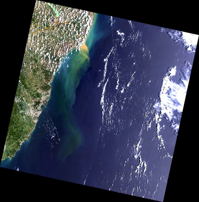
Rio Doce River 40 days after pollution by SAMARCO DAM in 16Dec2015
Free
Landsat 8 OLI Image, Ref. 215-075 WRS2, dated 16-dec-2015, processed to 15 m resolution with PAN sharpening, using bands 4-3-2 in R-G-B. over Rio Doce river in Espirito Santo. Use for navigation over the region. Covers part or entire municipalities of
Alfredo Chaves
Anchieta
Aracruz
Cari...
Alfredo Chaves
Anchieta
Aracruz
Cari...
Geographic area:
Category:
Imagery
Size:
427.92MB
Publication:
December 2015
Language:
Portuguese
This product is available exclusively in digital format, for use only in the Avenza Maps app.
Map bounds
Check nearby mapsWhat you get with Avenza Maps

Reliable mapping tools
Record GPS tracks, add placemarks, add photos, measure distances, and much more.

Locate yourself with GPS
Avenza Maps offline GPS app on your mobile device can locate you on any map, without WiFi or network connectivity.

The best maps by the best publishers
Download professionally curated digital maps on the Avenza Map Store from the best-renowned publishers.