Digital map for use exclusively in the Avenza Maps app
UBM-04 05-Ingar Andersons
- Cycling
- Hiking
This product can also be purchased as part of the following bundle(s).
$1.99 USD
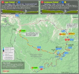
This map image provides mountain bike ride information for the Ingar and Anderson's Firetrail's rides where both start at Wentworth Falls and which finish at Woodford. This map is an extract from the map titled: Mountain Bike Rides MAP GUIDE Upper Blue Mountains, which is produced by Muddy Trail...
Geographic area:
Category:
Parks & Forests
Size:
10.23MB
Publication:
November 2016
Language:
English
This product is available exclusively in digital format, for use only in the Avenza Maps app.
Map bounds
Check nearby mapsWhat you get with Avenza Maps

Reliable mapping tools
Record GPS tracks, add placemarks, add photos, measure distances, and much more.

Locate yourself with GPS
Avenza Maps offline GPS app on your mobile device can locate you on any map, without WiFi or network connectivity.

The best maps by the best publishers
Download professionally curated digital maps on the Avenza Map Store from the best-renowned publishers.