

Digital map for use exclusively in the Avenza Maps app
USA Portrait 1976
$4.99 USD
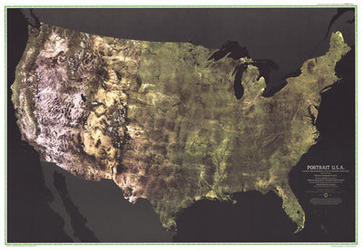
The first color satellite photomosaic of the 48 contiguous United States, this landmark map was published in July of 1976. The near-true color imagery showed the patchwork quilt of the contiguous 48 states as no image had done before. Trace the Mississippi river from its source to the Gulf of Mex...
Geographic area:
Category:
Educational
Size:
73.56MB
Publication:
1976
Language:
English
This product is available exclusively in digital format, for use only in the Avenza Maps app.
Map bounds
Check nearby mapsWhat you get with Avenza Maps

Reliable mapping tools
Record GPS tracks, add placemarks, add photos, measure distances, and much more.

Locate yourself with GPS
Avenza Maps offline GPS app on your mobile device can locate you on any map, without WiFi or network connectivity.

The best maps by the best publishers
Download professionally curated digital maps on the Avenza Map Store from the best-renowned publishers.