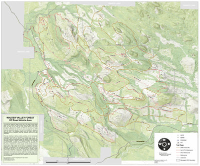


Walker ORV Park
- Hiking
- Off-roading
This product is available exclusively in digital format, for use only in the Avenza Maps app.
Map bounds
Check nearby maps- Reviews
- Questions
Walker ORV Park
Great Map
We only got to ride for a few hours. This map was a great help. We had two UTVs. It was really nice to know which trails were open to our type of vehicles. We ride mostly in the red rock of southern Utah and the mountains of northern New Mexico. We would have been totally lost in the forests of Washington without this map. This is only the second time I have used Avenza to create a track of our ride. It worked great even though we were in heavy timber most of the time.
What you get with Avenza Maps

Reliable mapping tools
Record GPS tracks, add placemarks, add photos, measure distances, and much more.

Locate yourself with GPS
Avenza Maps offline GPS app on your mobile device can locate you on any map, without WiFi or network connectivity.

The best maps by the best publishers
Download professionally curated digital maps on the Avenza Map Store from the best-renowned publishers.