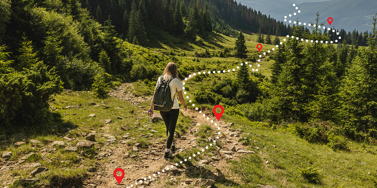
It is that time of the year when the sun is out, and so are all the adventurers. We are motivated to be out exploring and make lifelong memories when the weather is so nice and sunny. Finding a trail to connect with is always extra special. There are only so many times we can locate a trail with just the perfect amount of challenge and flora; these are the paths we will potentially desire to walk through again. This is when technology becomes a crucial part of our adventures. With the help of an app, we can track, record and share incredible routes and milestones.
The Avenza Maps App allows users to record their movements using GPS. While walking, hiking, running, biking, or doing anything else outdoors, the Record GPS Tracks feature records the route, speed, distance, and elevation. This is a valuable feature to have and use whether you have a specific personal goal to fulfill or simply want to keep track of all your outdoor activities.
How the Record GPS Track Feature Makes a Difference
We spoke to numerous Avenza Maps App users to learn how the Record GPS Track feature benefits them. One of the users stated that he was preparing for his first marathon and had set a specific distance as his objective. He marked that target with a pin, and on each run, he dropped a pin to mark the distance covered on that particular run, and he also used different colour tracks to assess the difference. The extensive documentation allowed the user to understand and evaluate his daily performance, which contributed to the marathon's successful completion.
Another user said she enjoyed organizing and documenting any hikes that she found particularly interesting and scenic. She would make notes on the routes, pin spots of interest, and geotag images for future reference. She did this frequently because she was generally the planner for outdoor activities within her friends and family circle and discovered that having some information helped her arrange exciting activities easily, especially because she had a few friends who don't like taking risks outdoors.
Have you explored the Recording GPS tracks feature on Avenza Maps? If you're a new visitor, the details provided below will help you understand how simple it is, and if you're already a pro user, here's a quick refresher.
Recording A Track
The Record GPS Tracks feature is compatible with any GPS-enabled device. GPS tracks are captured directly within a Map View, requiring a map to be open. Tracking will continue regardless of being off the map. Tracking can also occur across Map Collections as well. It is important to know that each device is different, and every user has a unique requirement for accurate tracking. The GPS settings can be customized to ensure accuracy based on outdoor activity (walking versus driving).
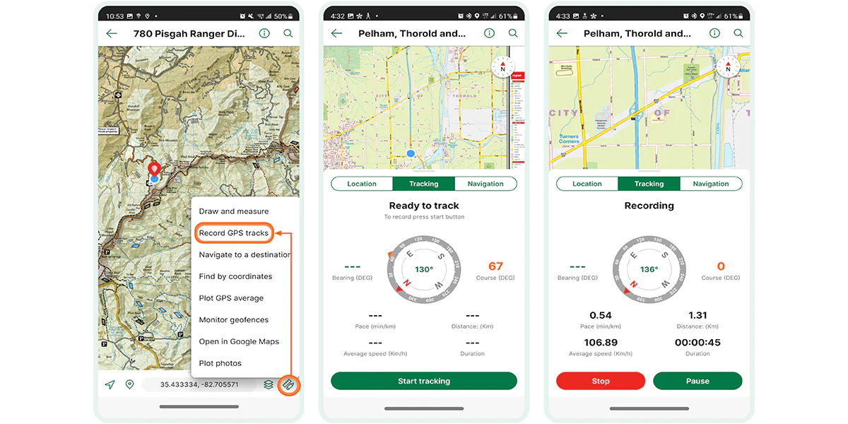
To record a GPS track:
- Have an appropriate map open that covers the desired area
- Tap the tools icon (found at the bottom right corner) and select Record GPS Tracks. Alternatively, you can swipe up on the Navigation bar and select "Tracking"
- Once a signal has been established (you will see "Ready to track" displayed), tap the “Start tracking” icon to start recording. Your tracks will continue recording even when you minimize the app.
- When you are done recording, tap 'Stop', and the track will be saved as a Map Feature. You also have the option to pause tracking instead by tapping ‘Pause’
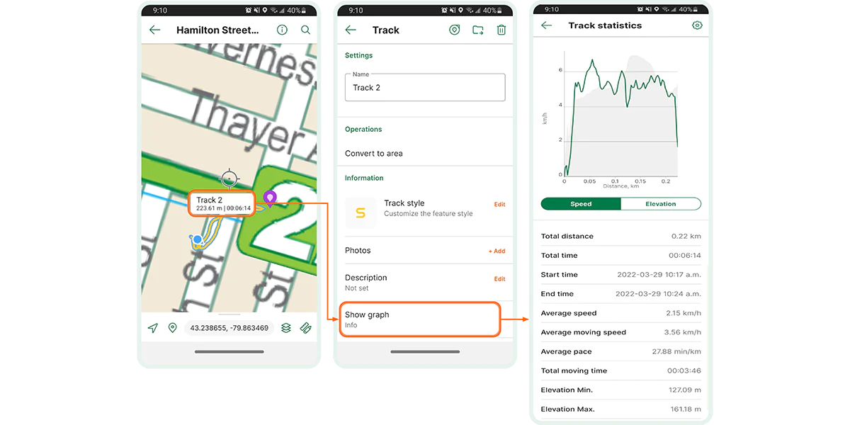
Viewing a Track
Once the recording is stopped, the track is automatically saved to the opened map. Tracks that have been saved can be seen on the map or exported for use on another device or software. To know more details about the saved track, tap the track to show its label, then tap the information icon. To view Track Statistics, tap on "Show Graph".
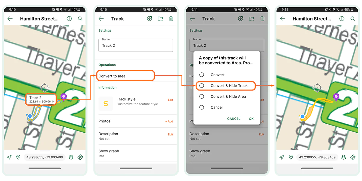
Track To Area (Pro Users)
This is a feature available exclusively to Avenza Maps Pro users. Pro users can covert a track to an area. To convert a track, select Convert To Area after seeing its details. Users will then have the option to Convert the Area, Convert and Hide Track, Convert and Hide the Area, or Cancel the action.
Did you enjoy learning how to Record GPS Tracks? Would you like to know more about our other features? Here is a quick guide on how to plot photos on a map using the Avenza Maps App.
Download Avenza Maps, the Best App for Recording GPS Tracks
We are looking forward to you going outdoors and having new fun-filled experiences. Try the Record GPS track feature on your next outdoor adventure and share your tracks and experience using the Avenza Maps app.
Download Avenza Maps, the #1 app for hiking, biking and all trails and enjoy an organized and hassle-free adventure.
 Scan this QR code to download the Avenza Maps app.